
The first hint wasn’t on a weather map, but on a quiet Tuesday morning. An email from a meteorologist friend simply read: “You’re going to want to watch the polar vortex this week.” No exclamation mark, no drama, just a screenshot of the upper atmosphere over the Arctic, colored in impossible shades of red and purple.
Scrolling on a phone screen, those colors don’t scream danger. They look almost pretty. Until you zoom in and realize what they mean: the icy engine that usually keeps Arctic cold locked up is being twisted, stretched, and punched out of shape right as we drift through February.
Somewhere between the calm blue of the forecast app and the blood-red blobs of the stratosphere, a quiet question forms.
What happens when winter’s “jail bars” suddenly snap?
A polar vortex disruption that barely fits the rulebook
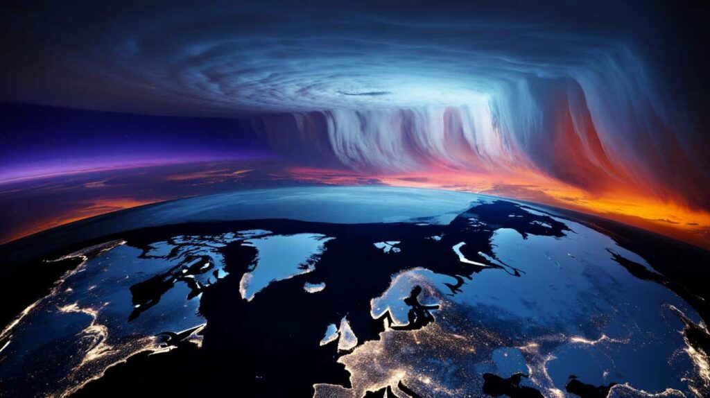
High above our heads, around 30 kilometers up, the polar vortex is supposed to spin like a clean, cold top in February. Steady. Predictable. Contained around the pole.
Instead, atmospheric models for the coming days show that spinning top wobbling wildly, almost splitting apart. The technical term is a “sudden stratospheric warming” event, but that phrase doesn’t capture the sheer weirdness of what’s unfolding.
For mid‑February, this scale of disruption is close to unheard of. Meteorologists are watching pressure charts that look less like winter and more like a broken record.
You can feel this story building in tiny, human ways. A school in the U.S. Midwest is quietly reviewing its remote-learning plan, just in case roads glaze over again. A farmer in northern Germany is calling seed suppliers, wondering whether to delay early planting because another random cold plunge might still be lurking.
Behind those decisions is a single, strange picture: the polar vortex being pulled like taffy by enormous planetary waves coming up from below. The models show temperatures in the stratosphere over the Arctic rising by 40–50°C in a few days.
That doesn’t mean balmy beach weather above the pole. It means the cold core weakens, pressure rises, and chunks of brutal air get dislodged, free to wander south.
This is where the story shifts from charts to real life. When the polar vortex is strong, Arctic cold tends to stay bottled up. When it’s disrupted or split, those cold “bottles” smash and spill across continents.
We’ve seen this before, but rarely with this timing and intensity. February is usually the moment the vortex starts its slow fade into spring, not a time for record-scale disruptions.
Climate scientists are still debating how a warming planet shapes these events, yet one thing is clear: a distorted vortex makes winter feel less like a season and more like a roulette wheel.
What this means down here: days, pipes, plans
For anyone just trying to live their life, the big question isn’t what the stratosphere is doing. It’s: what do I do with this information?
The practical answer starts with pattern-watching. If you live in North America, Europe, or parts of Asia, the coming weeks could bring sharp swings: a run of mild days that tricks you into packing away your coat, followed by a sudden, teeth‑chattering snap. The kind that can burst pipes, crack roads, and shut schools.
Being ready doesn’t mean panic-buying. It means treating late‑winter calm as a pause, not a promise.
We’ve all been there, that moment when the forecast said “a light dusting” and you woke up to a car buried to its mirrors. With a polar vortex disruption, that gap between expectation and reality can grow. Forecast models can see the upper‑air chaos, but translating that into street-level weather, two or three weeks ahead, is still messy.
That’s why meteorologists talk about “heightened risk” rather than certainty. You might not get a historic blizzard. You might just get three days of biting wind and black ice. Yet those three days are when people slip, deliveries stall, and heating bills jump.
Let’s be honest: nobody really updates their emergency kit every single day.
*The small, boring actions suddenly matter more than usual.*
This is the point where experts quietly repeat the basics, because they work when the atmosphere goes off-script.
A senior forecaster at the UK Met Office put it bluntly this week: “The polar vortex disruption doesn’t guarantee a ‘Beast from the East’, but it opens the door. Once that door is ajar, you don’t want to be the one standing outside without a coat.”
- Check your local 7–10 day forecast twice a week while this disruption plays out.
- Bleed radiators, wrap outdoor pipes, and clear gutters to avoid freeze‑thaw damage.
- Keep a minimal “cold snap kit”: flashlight, batteries, basic meds, power bank, and shelf‑stable food.
- Plan travel with a weather “Plan B”, especially for cross‑country trains and flights.
- If you’re vulnerable to cold, talk now with family or neighbors about a backup warm place.
A winter that doesn’t behave like winter anymore
Step back for a moment and this disruption feels like part of a wider pattern: seasons tipped slightly off their hinges. Late flowers, early mosquitoes, autumn heatwaves, snow in April. Then, right when you think winter has lost its bite, the atmosphere reaches down from the stratosphere and reminds you who’s still in charge.
This year’s polar vortex disturbance is more than a curiosity for weather nerds. It’s a live demonstration of how fragile our mental calendar of the seasons has become. We grew up thinking February had a script. That script is being quietly rewritten above our heads, in thin, dry air most of us will never see.
There’s also something oddly connecting about it. Someone in Tokyo, someone in Chicago, someone in Warsaw might all feel the same strange chill, born from the same warped swirl over the Arctic. You might scroll past a chart, shrug, and zip up your coat a little tighter without knowing why.
And that could be the new normal: less about smooth, predictable winters, more about learning to live with those sudden, unsettling lunges of cold. The question isn’t just “Will it snow?” anymore. It’s: how do we stay flexible, sane, and kind to each other when the seasons themselves start stuttering?
| Key point | Detail | Value for the reader |
|---|---|---|
| Unusual February disruption | Large‑scale sudden stratospheric warming is weakening and distorting the polar vortex | Helps explain why late winter may feel strange or extreme where you live |
| Increased cold‑snap risk | Displaced Arctic air masses can dive south weeks after the disruption begins | Gives a time window to prepare homes, travel, and routines |
| Practical readiness beats panic | Simple steps: monitor medium‑range forecasts, protect pipes, plan backup options | Reduces stress, costs, and disruption during any sudden cold outbreak |
FAQ:
- Question 1What exactly is the polar vortex, and should I be scared when it’s “disrupted”?
- Answer 1The polar vortex is a large zone of low pressure and strong winds spinning around the Arctic in the stratosphere. When it’s disrupted, it doesn’t mean instant disaster, but it can raise the chances of unusual cold spells and stormy weather in mid‑latitudes.
- Question 2Does a polar vortex disruption always mean heavy snow where I live?
- Answer 2No. It raises the risk of colder, more unsettled patterns, but local results vary. Some regions get intense snow, others just colder, drier air or a few sharp frosts. Local forecasts are still your best guide.
- Question 3How long after a disruption can the surface weather be affected?
- Answer 3Impacts usually appear 1–3 weeks after the main stratospheric warming, and can linger for several weeks. That’s why forecasters talk about a “window of risk” rather than a specific day.
- Question 4Is climate change making polar vortex disruptions more common?
- Answer 4Scientists are still debating this. Some studies suggest Arctic warming and changes in snow and sea ice may influence the vortex, but there’s no universal agreement yet. What most agree on is that a warmer world can still produce sharp winter extremes.
- Question 5What’s the one thing I should actually do after reading about this?
- Answer 5Spend five minutes checking a reliable 10‑day forecast and taking one small step to be ready for a cold snap—whether that’s wrapping a pipe, stocking basic supplies, or adjusting travel plans. Then keep an eye on updates, not on panic posts.