
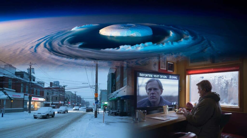
The first sign wasn’t on a satellite map or a model output. It was a frozen breath of air slipping under the door of a Minneapolis diner, where people in fleece jackets were quietly scrolling through their phones between sips of coffee. Outside, the sky looked calm, that washed-out winter blue that usually means “nothing much today.” Inside, the TV over the counter flashed a red banner: “Meteorologists warn: early February could unleash an Arctic breakdown.”
A woman in line pulled her scarf tighter, even though the draft hadn’t changed.

The phrase sounded dramatic, almost like headline overkill. Yet the scientists being interviewed didn’t look dramatic at all. They looked… worried.
 Parents who say they love their kids yet refuse to do these 9 things are pushing them away
Something in the atmosphere had snapped, they said.

And this time, the cold might not stay politely in the Arctic where we expect it to.
What meteorologists really mean by an “Arctic breakdown”
An Arctic breakdown doesn’t mean the North Pole suddenly marches south overnight. It starts far above our heads, around 30 kilometers up, in a layer of the atmosphere most of us never think about. Meteorologists call it the stratosphere, and in winter it usually holds a tight, spinning ring of frigid air over the Arctic called the polar vortex.
Right now, that ring is wobbling, stretching, and in parts, ripping apart.
When that happens, chunks of the Arctic’s deep cold can spill down into North America, Europe, and Asia in a way that feels less like winter and more like a system failure. Scientists tracking this in late January say early February could be the moment the atmosphere cashes that check.
If you lived through February 2021 in Texas, you already know what a broken polar vortex can do. That month, a violent outbreak of Arctic air plunged south, freezing pipelines, snapping power lines, and turning highways into sheets of black ice in cities that rarely see a snowflake. At least 240 people died, many in their own homes, as temperatures fell lower than parts of Alaska.
That event was linked to a disrupted polar vortex too. Not the only cause, but a key amplifier.
This winter, some of the same alarm bells are ringing: sudden warming high over the Arctic, models hinting at a split in the vortex, and long tendrils of cold forecast to dive toward mid-latitudes. It doesn’t guarantee a repeat of Texas 2021, though it raises the odds of wild temperature swings and brutal cold in places that thought they were nearly done with deep winter.
So what’s actually going on up there? In simple terms, the stratosphere above the Arctic has recently warmed by tens of degrees in just a few days, a phenomenon known as a sudden stratospheric warming. When that happens, the once-strong polar vortex starts to weaken and can even split into two or more “mini” vortices that slide south.
Near the ground, we don’t feel that high-altitude drama right away. It can take one to three weeks before the jet stream buckles and the cold air surges down into our weather.
Meteorologists watching those timelines say early February is exactly when the effects could hit, with the jet stream potentially forming deep dips over North America and Europe. That’s the shape that pulls Arctic air into our backyards and onto our heating bills.
How to read the warnings without spiraling into panic
If you glance at social media right now, the language around this Arctic breakdown swings between “nothingburger” and “Snowpocalypse 3.0.” The reality tends to sit somewhere in the messy, uncomfortable middle. The best move is to treat the warnings the way you would a slowly rising river: not urgent sirens at your door, but a clear sign to start adjusting your plans.
Look at the 7–10 day forecasts for your area, not the wild map that went viral with purple blobs over half the continent. That’s where the first realistic signals show up: dropping temperatures, a shift to northerly winds, maybe an uptick in snow chances.
Then think very locally. Cold doesn’t land the same in Oslo as it does in Atlanta.

A useful mental trick: plan like the cold will be one notch worse than your usual February, not ten. If you tend to coast through winter with a light jacket and half a tank of gas, upgrade that plan slightly.
Fill prescriptions earlier than usual in case icy roads make a quick pharmacy run impossible. Check where your shutoff valve is in case a pipe bursts. Call older relatives and ask what they’d do if the power went out for 12 hours.
We’ve all been there, that moment when the forecast suddenly escalates overnight and shelves empty faster than you thought possible. Starting small, a week ahead, feels oddly calming because you’re no longer just a spectator in front of your weather app.
The truth that often gets lost in the noise is simple: *cold is only a crisis when it meets unprepared systems.*
“From a science standpoint, an Arctic breakdown isn’t just about low temperatures,” climatologist Jennifer Francis told me. “It’s about exposure. Homes, grids, transit networks, people’s budgets — they’re all tuned to ‘normal’ winter. When the jet stream brings a taste of the Arctic where it doesn’t usually belong, that mismatch becomes dangerous fast.”
- Check your home’s weak spotsWalk around with your hand near doors, windows, and outlets on exterior walls. Drafts now become frozen pipes later.
- Prepare a simple “cold kit”Throw a flashlight, batteries, blankets, power bank, and basic meds into one bag. You hope it gathers dust.
- Layer your plans, not just your clothesHave a “normal cold” plan, a “roads are icy” plan, and a “short power cut” plan. Each is small, but together they’re powerful.
- Watch local meteorologists, not just viral mapsThey know which valleys frost over first and which neighborhoods always lose power.
- Share info, not fearForward practical tips to group chats. Ask neighbors what they need. Quiet coordination beats loud panic.
The deeper worry scientists won’t just shrug off
Once you zoom out from early February’s forecasts, the “deeply concerning” part of this Arctic breakdown isn’t just the cold snap itself. It’s the pattern. In the last decade, sudden stratospheric warmings and polar vortex disruptions have appeared more frequently in discussions around extreme winter weather, especially in the mid-latitudes.
Some researchers are now pointing to a disturbing feedback loop: as the Arctic warms faster than the rest of the planet, the temperature contrast that helps keep the polar vortex tight and tidy may be weakening. A sloppier vortex means more opportunities for cold air to escape.
So we end up in this strange world where global warming coexists with brutal local cold spells. It feels contradictory, but it’s not. It’s the climate system fraying at the edges.
Let’s be honest: nobody really reads a climate paper every single day. Most of us experience climate through our utility bills, our commutes, and conversations in supermarket lines when the weather gets weird again.
Early February’s Arctic breakdown warning slides right into that lived reality. Maybe you’re already paying more for heating. Maybe last summer’s heat waves left you more tired than you expected. Now scientists say, “By the way, the old rules of winter might be shifting too.”
That doesn’t mean every cold snap is proof of climate change. Weather is still noisy, still stubbornly chaotic. But when the same types of disruptions keep popping up in model runs and real life, researchers start connecting dots — and asking if this is our new normal or just the early wobble of something bigger.
There’s a quiet choice sitting underneath all these alerts and maps. On one hand, you can treat the Arctic breakdown as just another scare story that will blow over by March. Spring will come, crocuses will push through, and the memory of frozen sidewalks will blur into last year’s winter memes.
On the other hand, you can treat this as a rehearsal. A reminder that our cities, homes, and even our expectations were built for a climate that’s already slipping through our fingers.
How we respond — calmly, with neighbors, with a bit more curiosity about what the scientists are really saying — might matter more than whether your own street ends up under fresh snow next week.
| Key point | Detail | Value for the reader |
|---|---|---|
| What an Arctic breakdown is | Disruption of the polar vortex after sudden warming high over the Arctic, sending pockets of frigid air south | Helps you understand why forecasts for early February sound so alarming |
| How it might affect your daily life | Greater risk of intense cold snaps, power disruptions, icy roads, and stress on heating systems | Gives you a concrete reason to prepare, not just worry |
| Practical ways to get ready | Home checks, simple “cold kit,” layered backup plans, and staying tuned to local forecasters | Turns a vague climate warning into specific, doable actions you can take this week |
FAQ:
- Question 1What exactly is breaking down during an “Arctic breakdown”?
- Question 2Does an Arctic breakdown mean every region will see extreme cold?
- Question 3How long could the early February cold from this event last?
- Question 4Is this directly caused by climate change?
- Question 5What are the most useful steps I can take right now to prepare?