
Scientists are now warning that it is not just the amount of rain that matters, but the way it falls, with brief, violent downpours becoming a growing driver of flash floods.
Shorter storms, sharper floods
Across central Europe, meteorologists have noticed a clear trend: rainfall is getting more erratic. Gentle, steady rain is giving way to intense cloudbursts that dump huge volumes of water in a short time.

A team of Austrian researchers, writing in the journal Nature, analysed more than a century of rainfall records. They compared slow, multi-day rain events with rapid storms lasting just a few hours. The two types of rain are both linked to a warming climate, but not in the same way.

Short, intense downpours are increasing much faster than long, gentle rainfalls as temperatures rise.

In Austria, short-duration rainfall has increased by about 15% over the past 40 years. The pattern appears on both sides of the Alps, even though the surrounding regions have different local climates. That suggests a broad shift in atmospheric behaviour rather than a local quirk.
Warmer air, more explosive storms
The basic physics is fairly straightforward. Warmer air can hold more moisture, and it also tends to rise faster. This boosts what meteorologists call convection: warm, humid air races upwards, cools, and condenses into towering storm clouds.
Those clouds can release their cargo of water in a sudden, violent burst instead of spreading it out over several days. The result is a storm that feels almost tropical, even in relatively cool countries.
The added heat in the atmosphere acts like fuel, turning ordinary showers into explosive thunderstorms.
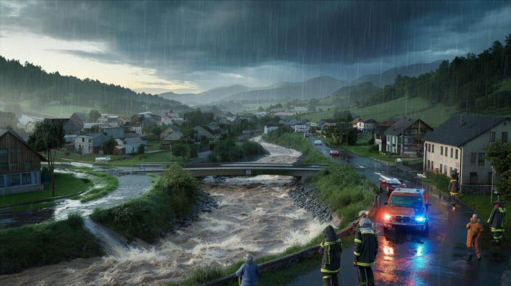
For small rivers and streams, that makes a huge difference. Narrow channels and steep catchments react in minutes, not hours. What looks like a harmless trickle in the morning can become a churning brown flood by late afternoon if a storm stalls overhead.
Why big rivers behave differently
Large rivers such as the Danube respond in another way. Their vast drainage basins smooth out the impact of a single cloudburst. Even when a local downpour is extreme, the main river often rises slowly, giving more time for warnings and evacuations.
Big rivers are more sensitive to long-lasting rain events spread over several days and across wider areas. When the ground is already saturated and rain keeps falling, water has nowhere to go. That is when major, basin-wide floods tend to occur.
- Short, intense storms: high risk for small streams and flash floods
- Long, persistent rain: higher impact on large rivers and regional flooding
- Warming climate: amplifies both patterns, but especially the short storms
Flash floods: from trickle to torrent
For communities situated along small watercourses, the new rainfall regime is particularly alarming. These streams often run low or nearly dry for much of the year. They are easy to ignore, and many homes, roads and car parks have been built right next to them.
When a short, violent storm hits, these same streams can turn into destructive torrents. Culverts clog with debris, bridges catch tree trunks, and water rapidly backs up into streets and ground floors.
Flash floods are fast, noisy and brutal, leaving residents with little time to react or evacuate.
Because they develop so quickly, flash floods are hard to forecast. Even when meteorological services issue warnings for heavy rain, pinpointing exactly which valley or village will be hit remains a technical challenge.
Why Mediterranean countries are different
The Austrian findings do not apply evenly across Europe. Regions around the Mediterranean, such as Spain, Italy and Greece, are following a more complex pattern.

As temperatures climb there, the atmosphere often becomes drier for long stretches of the year. That can limit the formation of storms and reduce the frequency of heavy rainfall in some seasons.
In Mediterranean climates, rising temperatures can dry the air enough to offset part of the intensification of short downpours.
This does not mean those countries are safe from flash floods. The Mediterranean is already known for “medicanes” and violent autumn storms that can trigger deadly flooding. But the general trend seen in Austria – a clear, steady rise in short, intense rainfall events – is less straightforward in these warmer, often drier regions.
What about France and neighbouring countries?
The study focused on Austria, but its conclusions raise questions for nearby regions. Northern and eastern France share several climatic features with central Europe. Climatologists expect those areas to show similar shifts toward more intense short-duration rain in the coming decades.
By contrast, southern France, under stronger Mediterranean influence, is likely to behave more like Spain or Italy. There, the balance between drying trends and occasional extreme storms will decide how flood risks evolve.
How cities and towns should adapt
Urban areas are especially exposed when rainfall patterns change. Tarmac, concrete and rooftops block water from soaking into the ground. During a cloudburst, runoff races straight into drains and culverts, which are often designed based on old rainfall statistics.
As short, intense storms become more frequent, many drainage systems will prove undersized. Local planners and engineers are starting to rethink how they manage water in cities.
| Measure | How it helps against flash floods |
|---|---|
| Wider river buffers | Gives streams more room to swell without flooding homes |
| Green roofs and permeable pavements | Let rain soak in slowly rather than rushing to drains |
| Retention basins and ponds | Temporarily store stormwater during peak downpours |
| Updated flood maps | Reflect new rainfall patterns and highlight emerging danger zones |
Key terms behind the science
Much of the discussion revolves around concepts that sound technical but describe simple processes. Convection, for instance, is just the vertical movement of warm air. On a hot day, dark surfaces heat the air above them, which then rises like a balloon, carrying moisture upwards.
Once high enough, that air cools and condenses into droplets or ice crystals. If the updraft is strong, clouds grow tall and heavy, and rain falls in intense bursts. As the planet warms, these convective events receive more energy, helping explain the recent spike in short, violent storms.
Another key idea is “return period”, often used in flood risk communication. A so‑called “100‑year flood” does not mean it happens only once every century. It means there is a 1% chance of such an event in any given year. Changing rainfall patterns can turn a 100‑year event into something that happens far more often than the name suggests.
Everyday scenarios and cumulative pressures
On the ground, the new rainfall regime interacts with other human choices. Urbanisation increases hard surfaces. Deforestation and intensive agriculture reduce the soil’s ability to hold water. Small, separate decisions add up to a landscape that sheds rain faster and more violently.
Imagine a modest storm over a wooded valley fifty years ago. Trees, undergrowth and deep soils would have soaked up a large share of the rain. The same storm today, over a valley with more roads, housing estates and compacted fields, will send much more water straight into the nearest stream. When that storm is also 15% more intense than it used to be, the odds of a flash flood rise sharply.
Insurance companies, emergency planners and residents all need to account for this invisible shift in rainfall. What looks like a minor tweak in storm intensity on paper can translate into flooded basements, washed‑out roads and lives abruptly disrupted when the next “brief shower” turns into something far more dangerous.