
The first real hint arrived not on a satellite image, but on a smartphone screen. In the half-light of an early morning commute, people scrolling through weather apps started noticing strange new colors creeping over the maps: deep purples, almost black, sliding south from the Arctic like spilled ink. Forecast discussion threads turned anxious. Meteorologists who usually post calm, nerdy charts late at night suddenly sounded… keyed up. One of them, in Oklahoma, wrote simply: “Early February is starting to look… different.”
Outside, the air felt wrong too. Not just cold or mild, but jumpy, unstable, like the season hadn’t quite decided what it wanted to be. We’ve all been there, that moment when you watch the sky and sense something is off, even if you can’t name it.

This time, scientists can name it.

What an “Arctic destabilization event” really means for your street
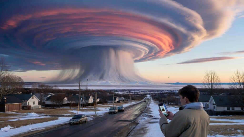
The phrase sounds like a movie trailer: “Arctic destabilization event.” Yet for meteorologists watching the high atmosphere right now, it’s not drama, it’s data. Around the North Pole, a spinning band of icy air known as the polar vortex usually acts like a lid, trapping the deepest cold far to the north. Early February, that lid may start to wobble.
When it does, the cold doesn’t just “move south” in a neat line. It fractures into lobes and tongues, pushing brutal Arctic air over cities that just had spring-like afternoons. That’s why you can barbecue in a hoodie on Sunday and be scraping ice off your windshield on Wednesday. The sky doesn’t care about our sense of order.
Meteorologist Judah Cohen, one of the leading experts on these patterns, has been flagging a brewing disruption in the stratosphere — the layer of air about 10 to 30 miles above us. It’s called a sudden stratospheric warming, when that high-altitude air rapidly heats up, flipping the usual circulation upside down.
A similar set‑up happened in February 2021, weeks before the Texas deep freeze that shattered pipes and power grids across the state. Back then, models hinted at trouble, but most people didn’t take out their winter boots until it was too late. Now, some of those same forecasters are warning that early February 2026 might be the opening move of a comparable pattern, though not a carbon copy.
So what’s actually destabilizing? Not the Arctic as a place, but the balance between deep polar cold and the rest of the hemisphere. Warmer oceans and shrinking sea ice are pumping extra heat and moisture into the atmosphere, bending the jet stream into more dramatic loops. Those loops can stall storms, lock in weird temperature swings, and send “out-of-place” weather hundreds or thousands of miles from where you’d expect it.
*The plain truth: our old mental map of winter—steady, predictable, slowly fading into spring—just doesn’t match the new physics overhead.*
How to live through a destabilized winter without losing your mind
When meteorologists start whispering about Arctic destabilization, you don’t need to become a climate scientist overnight. You do need a simple, almost boring routine. Think of it as a “three-day buffer rule”: always be three days ahead of the weather.
That means glancing not only at the temperature, but the pattern. Is your area about to swing 20–30°F in a couple of days? That’s your cue. Gas up the car before the front hits. Charge devices. Run the dishwasher, laundry, and anything that would be a pain to deal with in an outage. One quiet preparation day while the sky is still calm can save you from that frantic, everyone-at-the-store-at-once scramble.
A lot of people feel silly preparing when the day outside looks totally normal. There’s sunshine, kids at the park, maybe someone in shorts, and your brain tells you the forecast feels exaggerated. Let’s be honest: nobody really treats every wild-looking forecast like a serious warning.
The common mistake isn’t failing to buy survival gear; it’s underestimating the chain reaction of small things when the cold actually hits. Water bottles left in the car freeze and burst. A half-charged phone dies just when you need directions. A pet’s outdoor water dish turns to solid ice overnight. Little annoyances stack into real stress, especially for older neighbors or anyone with health issues.
Meteorologists don’t want people panicking. They want people listening early, when there’s still room to act in ordinary ways.
“Arctic destabilization doesn’t guarantee a historic disaster where you live,” explains a veteran forecaster from Minneapolis, “but it does raise the odds of ‘once-a-decade’ cold shots and surprise storms showing up out of season. The point isn’t fear — it’s respect for the pattern.”
- Watch the trend, not just the daily high
Look for sharp swings in the 3–7 day outlook, not just if Friday looks “nice” or “awful”. - Build a tiny winter buffer kit
A flashlight, spare batteries, power bank, basic meds, and shelf-stable food for 48–72 hours is enough for most events. - Stay local, but think regional
Ask: if the grid stumbled or roads iced over for a day or two across my region, what would I wish I had done yesterday?
The bigger picture: when winter stops behaving like winter
Early February 2026 may end up being remembered as just “a weird winter stretch.” Or it might be the month your kids later describe as the first time they realized the seasons weren’t playing by the old rules. That’s the unsettling part of Arctic destabilization: the outcomes are probabilistic, but the direction of travel is clear. Colder colds in some bursts, softer winters overall, and a roller‑coaster feeling in between.
People who never thought of themselves as “weather people” are starting to pay attention. Farmers watching frost dates creep and slip. City planners recalculating how much salt to stock. Parents trying to guess if that school ski trip in mid‑February will be powder or mud. The science is technical, but the lived experience is immediate: do I need gloves this morning or sunglasses, or somehow… both?
The next few weeks will offer clues. If the polar vortex indeed buckles, some regions will likely face punishing cold bursts, others strange warmth, and a few both in rapid succession. Either way, the best response is neither denial nor doom, but a quiet, stubborn kind of adaptation. Listen a bit more closely. Prepare a bit earlier. Talk about what you’re seeing with the people around you. Weather was always a shared language; now, it may also be our first draft of how to live on a changing planet.
| Key point | Detail | Value for the reader |
|---|---|---|
| Arctic destabilization changes winter patterns | Shifts in the polar vortex and jet stream can create extreme swings in temperature and snowfall far from the Arctic | Helps you understand why local weather feels “off” and less predictable than in the past |
| Early warning signs matter | Sudden stratospheric warming events and model trends in late January can hint at early‑February cold waves | Gives you extra days to prepare calmly before a potential cold blast or disruptive storm |
| Small preparations beat last‑minute panic | Keeping a 3‑day buffer of supplies, power, and information reduces stress during abrupt weather shifts | Makes your household more resilient without expensive gear or drastic lifestyle changes |
FAQ:
- Question 1What exactly is an Arctic destabilization event?
- Answer 1It’s when the usual balance between the frozen Arctic and the mid‑latitudes breaks down, often due to changes in the polar vortex and jet stream. Cold air that normally stays bottled up near the pole can surge south, while some Arctic areas briefly warm.
- Question 2Does this mean everywhere will get a deep freeze in early February?
- Answer 2No. A destabilized Arctic rearranges where the extremes land. Some regions may get intense cold, others unusual warmth, and some a mix of both in quick succession. The risk of “out-of-season” or “out-of-place” weather simply goes up.
- Question 3Is this the same thing as the polar vortex “escaping”?
- Answer 3Not exactly. The polar vortex is always there. During certain events, it weakens or splits, letting lobes of very cold air slide south. Media headlines often say the vortex “escaped,” but technically the circulation was disrupted, not destroyed.
- Question 4Is climate change causing this destabilization?
- Answer 4Most researchers see a connection between warming oceans, shrinking sea ice, and a wobblier jet stream. The science is still evolving, but there’s growing evidence that a warmer world can produce sharper winter extremes in some regions.
- Question 5What’s the simplest thing I can do if my area is in the risk zone?
- Answer 5Follow trusted local forecasts closely for the next 7–10 days and build a low‑key 72‑hour buffer: charged devices, basic food and meds, warm layers, and a plan to check on vulnerable neighbors or relatives if the weather turns fast.