
While most people picture frigates and submarines when they think of maritime power, France’s real long-term advantage may lie in its maps, measurements and underwater data — and in a service that predates the French Revolution by almost a century.
A 305-year-old secret behind France’s maritime power
France likes to remind the world of its cuisine, luxury brands and nuclear fleet. It rarely talks about its hydrographers. Yet the Service Hydrographique et Océanographique de la Marine, better known as SHOM, has been quietly operating since 1720 — giving France the record for the oldest continuously active hydrographic service on the planet, ahead of Britain’s own prestigious UK Hydrographic Office, created in 1795.

France has run an official hydrographic service for 305 years, making it older than the British, American and Japanese equivalents.

Born as the “Dépôt des cartes et plans de la Marine” under the French monarchy, the service was set up to make accurate nautical charts at a time when map errors could sink a fleet. The institution has survived kings, revolutions, empires and republics without interruption, constantly updating how France reads the ocean.
 Parents who say they love their kids yet refuse to do these 9 things are pushing them away
Today, SHOM is a public body attached to the Ministry of the Armed Forces. Its job sounds technical, almost bureaucratic: produce and share reference maritime geographic data. In reality, its work underpins how France manages an Exclusive Economic Zone (EEZ) of more than 11 million square kilometres — the second-largest on Earth after the United States.
Three core missions beneath the waves
SHOM’s mandate can be broken down into three major roles that reach from shipping to climate policy.
1. Keeping ships off the rocks
The first role is national hydrography. SHOM maps the seabed, measures depths and identifies underwater hazards. Every buoy, port approach and shipping lane depends on this work.
- Depth measurements for safe navigation
- Identification of reefs, wrecks and shoals
- Design of port access routes and channels
- Official nautical charts for civilian and military crews
Without updated charts, ports become risky, insurance premiums rise and large cargo ships are forced to slow down or reroute. In a global economy where 80–90% of trade moves by sea, that data quietly keeps supply chains running.
2. Fuel for military planning
The second role is support to defence. Warships, submarines and maritime patrol aircraft all need precise knowledge of the seabed and coastal waters. Acoustic conditions affect sonar. Underwater slopes shape how submarines hide and move. Even amphibious operations depend on accurately knowing beach gradients and tidal behaviour.
French naval weapon systems, mine warfare, and submarine patrol routes are built on data produced or validated by SHOM. As tensions grow in contested seas from the Indo-Pacific to the Arctic, such “background” information becomes a strategic asset.
3. Data for climate and coastal policies
The third role concerns public policy. Coastal erosion, flooding risks and rising sea levels are now central concerns for mayors and national planners. SHOM provides datasets and models that help:
- Assess the impact of storms on low-lying coasts
- Track shoreline retreat and sediment movement
- Support offshore wind and tidal energy projects
- Plan adaptation to climate change along the French coastline
Local authorities and environmental agencies use SHOM’s information as a decision-making tool, even if the institution’s name rarely appears in public debates.
France vs UK: a quiet race in ocean knowledge
The historical comparison is striking. Britain’s sea power is often associated with the Royal Navy and the UK Hydrographic Office. Yet France’s equivalent predates it by 75 years. A few key dates illustrate that lead:
| Country | Hydrographic service | Creation year | Continuity | Notable feature |
|---|---|---|---|---|
| France | SHOM | 1720 | Unbroken | Oldest official hydrographic service still active |
| United Kingdom | UK Hydrographic Office | 1795 | Yes | Backbone of British naval expansion |
| United States | Office of Coast Survey (NOAA) | 1807 | Yes (evolving) | Strong scientific and civilian focus |
Over three centuries, SHOM has changed names and legal status but kept its core mission: know the sea to control how it is used. In 1886 it became the Marine Hydrographic Service. In 1971, oceanography was added to its remit, expanding from pure charting to physical study of the ocean. In 2007, it took its current form as an administrative public body.
Drones and AI: how a royal archive turned high-tech
Autonomous surface and underwater drones
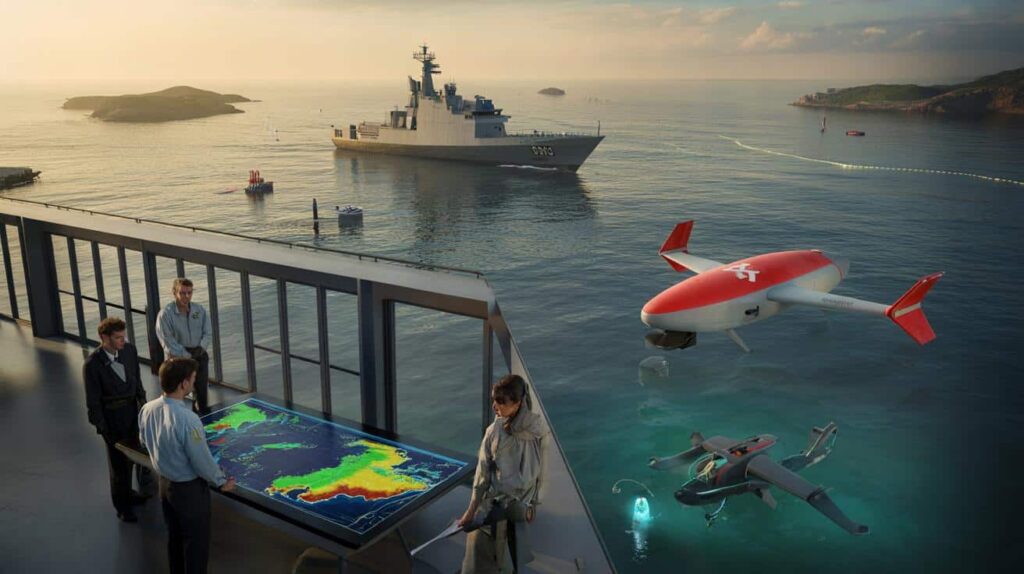
Despite its age, SHOM is not stuck in the age of compass and sextant. The service is in the middle of a technological transformation aimed at continuous, automated data collection. Recent acquisitions tell the story.
One of its new tools is the DriX H-9, a sleek autonomous surface drone built by French company Exail. It can operate alone or alongside a larger hydrographic vessel. While the main ship focuses on complex tasks, the DriX sweeps large zones, records depths and spots anomalies, all with reduced crew and fuel use.
Another addition is NemoSens, a small autonomous underwater drone from RTSys. Designed for continental shelf areas that are shallow, cluttered or just hard for conventional ships to work in, NemoSens slips into tight spaces, gathers data and sends it back for analysis.

Robotic platforms let France map more ocean, more often, without sending large crews into difficult or dangerous waters.
These two join Marlin, a DriX H-8 drone received in late 2025, and they will soon be complemented by a deep-diving Hugin Superior autonomous underwater vehicle, capable of working down to 6,000 metres, built by Norway’s Kongsberg Discovery.
From occasional surveys to permanent sensing
Historically, hydrographic work was done in campaigns: a ship went out, surveyed, returned, processed the data. SHOM now wants to shift towards a more continuous approach, closer to a “sensor network” spread across French waters and overseas territories.
Drones are only half the story. The other half lies in data processing. Artificial intelligence is used to sort and classify the massive streams of information coming from sonar, lidar and other instruments. Automated bathymetric processing helps turn raw depth measurements into navigationally useful maps. Predictive models simulate how seabeds and shorelines may evolve over years or decades.
In that sense, technology has moved from being a tool at the edge of the process to the central engine of SHOM’s activity.
Why ocean data equals sovereignty
The stakes stretch far beyond scientific curiosity. Undersea cables now carry the vast majority of global internet traffic. EEZs concentrate fish stocks, energy resources and potential seabed minerals. In these areas, ignorance is weakness.
Relying on foreign underwater data would expose a country to blind spots and outside influence at the exact moment when oceans are turning into strategic frontiers.
By keeping the capacity to chart, measure and model its own waters, France strengthens its maritime sovereignty. SHOM’s datasets support arguments in boundary negotiations, legal cases over continental shelves and international discussions on resource use.
The same data also helps assess the risks and benefits of offshore infrastructure: wind farms, hydrogen production projects, or even large-scale aquaculture platforms. In a more crowded ocean, knowing where cables run, where currents are strongest and where seabeds are unstable becomes decisive.
Key terms and real-world scenarios
Two expressions come up repeatedly in discussions around SHOM: hydrography and EEZ.
Hydrography is the science of measuring and describing physical features of oceans, seas, coastal areas, lakes and rivers. It focuses on depth, shape of the seabed, tides and currents. This differs from oceanography, which looks more broadly at chemical, physical and biological processes.
The Exclusive Economic Zone (EEZ) is a band of sea extending up to 200 nautical miles from a country’s coast where that state has special rights to exploit resources. Thanks to territories like New Caledonia, French Polynesia or Réunion, France’s EEZ totals over 11 million square kilometres, spread across multiple oceans. Mapping and monitoring all that space is a permanent challenge.
A simple scenario illustrates how this plays out. Imagine a new undersea cable planned between Europe and the Caribbean. Engineers need accurate relief maps to avoid underwater canyons and unstable slopes, as well as knowledge of seismic activity and sediment flows. Military planners want to know whether the route will be easy or hard to monitor and protect. Environmental agencies need to check if the cable crosses sensitive habitats. At every step, SHOM’s data becomes part of the decision-making chain.
Another example concerns climate adaptation. A coastal town in Brittany or Guadeloupe wants to know where to reinforce sea defences and where retreat might be cheaper and safer. High-resolution elevation data, tide records and storm surge models feed into cost–benefit calculations for decades ahead. Again, this rests on measurements that start with hydrographic surveys.
France’s three-century head start in structure and practice does not automatically guarantee future success. But it gives the country a dense institutional memory, huge archives and a culture of methodical ocean measurement. Combined with drones and AI, that quiet legacy could shape how a major maritime nation navigates the next 300 years.