
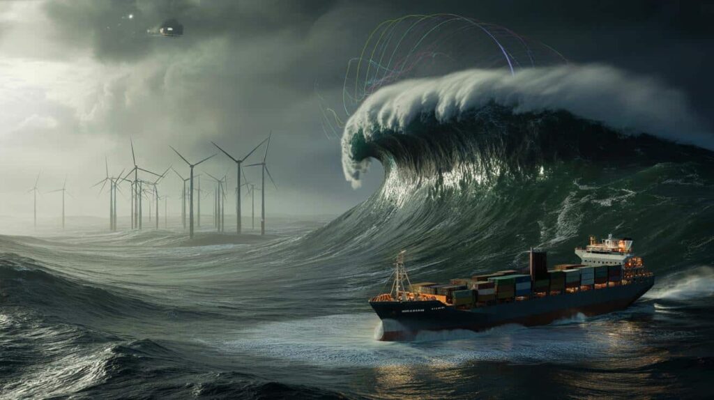
The captain saw it first, a wall of black water rising where there should have been only moonlight and swell. On the bridge cameras, the Pacific looked wrong, like the horizon had been bent upwards by an invisible hand. Alarms started chiming, crew boots hit metal stairs, and for a few long seconds the ship felt very, very small. Out in the dark, 35 metres of fast-moving ocean reared up, then crashed past them, close enough to taste the salt when it turned to spray.
Thousands of kilometers above, a satellite watched the same wave.

Its data would end up on a scientist’s screen, then in a heated email thread, then in an uncomfortable meeting with people who care more about megawatts and freight schedules than about sailors staring at the ceiling of the sea.

That’s where the story really begins.

Satellites are catching waves we used to call “myth”
From space, the Pacific doesn’t look wild. It looks patterned, almost gentle, a slow, moving fabric of blues. But when researchers stitched together months of satellite radar data last winter, a brutal truth appeared in the pixels. In several storm systems between Hawaii and the US West Coast, the ocean was throwing up waves as high as a 12-storey building. These weren’t one-in-a-century monsters. They were repeating shapes, like fingerprints of a climate that’s learning new tricks.
The satellites caught not just the heights, but the terrifying speed and angle of these waves, the way they stalked shipping lanes and future offshore wind zones like predators.
Ask oceanographer Lara Ruiz what shocked her most, and she doesn’t mention the 35 metres. She talks about the pattern. In November, her team tracked a series of powerful storms in the North Pacific. One wave train, powered by a low-pressure system the size of Alaska, lined up almost perfectly with a corridor used by container ships leaving China for Los Angeles.
One freighter reported a near knockdown, losing containers overboard. A week later, a different vessel, same corridor, reported superstructure damage. Ruiz pulled the satellite snapshots and felt her stomach drop. The worst of the waves passed exactly over the paths those ships had sailed, like a sniper’s laser passing over a moving target.
For decades, mariners called these “rogue waves”, freak events that came from nowhere and disappeared just as fast. The science used to shrug and say they were almost impossible to predict. With satellite altimetry and synthetic aperture radar, that excuse is dying. We see structures in the chaos now: storm tracks feeding long, deep swells; intersecting systems that stack waves on top of each other; wind fields that whip the tops into explosive crests.
The more clearly the satellites see, the harder it is for anyone to plausibly say, “We had no idea.” And this is where the argument starts: once you can see the bullets, how long can you keep walking your people through the firing line?
Are we building in the crosshairs on purpose?
On a gray morning off the coast of California, a small research vessel nudges close to a circle of bright-yellow buoys. This patch of ocean, at first glance, is just waves and seabirds. In a few years, if developers get their way, it will be the skeleton of a massive floating wind farm. Gigantic turbines anchored to the seabed, blades sweeping arcs bigger than football fields, all standing in waters where those same satellites recently spotted 30+ metre waves tearing across the grid square.
Engineers aboard the little boat toss in instruments, check moorings, and talk quietly about “return periods” and “extreme loads”, as if naming the danger makes it polite.
There’s a tender sort of optimism in the way offshore wind brochures are written. Blue horizons. Clean energy. Happy families plugged into invisible power lines. Then you look at the technical annex, where design criteria mention “significant wave height” numbers that sound solid, conservative, reasonable. Climate reality, caught by satellites, is starting to outgrow those spreadsheets. Last year, a European floating turbine prototype in the North Atlantic recorded forces close to its design limit twice in a single winter. On paper, those kinds of loads were supposed to happen once in 50 years.

“We’re not just flirting with the edge,” a structural engineer told me. “We’re dancing on it to meet political deadlines.”
This is the friction point: energy transition timelines versus the messy, rising ocean. Developers argue that if we upgrade every design to withstand the absolute worst-case waves projected by the latest satellite data, projects will stall or die. Costs explode. Permits drag. Competing countries, less cautious, grab the investment. Critics respond that we’re accepting failure as a line item. A small but vocal group of marine scientists and safety experts are asking a blunt question: are we quietly pricing in lost ships and crippled turbines as if they were just another form of wear and tear?
Let’s be honest: nobody really reads those risk tables outside the room where they’re written. And yet that’s where the trade‑off between profit and sacrifice quietly hardens into policy.
Reading the ocean like a weathered old captain (with satellites in your pocket)
If you talk to veteran captains, they don’t start with algorithms. They start with the way the hull shudders when a long swell meets a cross-sea, or how the horizon “tightens” before a bad front. What’s new is that their gut feeling now has a satellite feed. Modern routing software overlays near-real-time wave height data, storm tracks, and historical extremes. One captain showed me his tablet: a thin green line for the “fastest” route, a thicker yellow one bending away from the nastiest satellite-detected peaks. He tapped the yellow line. “This one costs us fuel and time,” he said. “This one keeps me sleeping at night.”
The precise method, in simple terms, is choosing the yellow line more often, even when the spreadsheet hates it.
The same mindset could guide offshore wind. Instead of only asking, “Can this turbine survive a 50-year storm?”, designers can layer satellite archives over proposed sites and ask, “What did this patch of ocean actually do in the last 20 years, and how is that trending?” The mistake many teams fall into is treating wave data as a static baseline instead of a living, shifting threat. You see it when developers downplay the outliers as “anomalies” rather than **warnings**.
We’ve all been there, that moment when data tells us something uncomfortable and we quietly file it under “unlikely” because changing plans is expensive, political, or just exhausting.
Scientists like Ruiz are starting to say this out loud: “When satellites show 30 to 35 metre waves crossing future wind zones, and we still sign off on designs that barely acknowledge that, we’re not being surprised by nature, we’re gambling against it.”
- Watch the extremes, not just the averages
Those 1% of highest waves, mapped from space, are the ones that break ships and bend steel. - Push for transparent wave data in public project files
If you live near a planned offshore wind site, ask what the design wave assumptions are and whether they include the latest satellite records. - Question the “once in 50 years” comfort phrase
Climate-shifted oceans are rewriting those odds much faster than old models suggested. - *Treat rerouting and over‑engineering as the new safety minimum, not a luxury upsell.*
The real fear isn’t the wave, it’s the quiet compromise
The image that sticks with me isn’t the dramatic satellite map with tall red spikes of wave height. It’s the conference room where that image is projected, then gently talked around. Someone points at the color scale, someone else says the word “contingency”, and slowly the edges get sanded down until they fit inside a business plan. A few more gigawatts approved. A few more ships told they’ll be fine most of the time.
The terrifying part isn’t a single 35 metre wave smashing into steel. It’s the casual, almost sleepy way we accept that risk as the cost of moving fast and staying competitive.
| Key point | Detail | Value for the reader |
|---|---|---|
| Satellites see waves we once called “freaks” | Radar and altimetry data reveal recurring 30–35 m waves in key Pacific corridors | Understand that today’s ocean risks are mapped, not mysterious |
| Shipping routes and wind farms overlap danger zones | High-value infrastructure is being planned directly in paths of recorded extremes | Spot where economic choices may be quietly outrunning safety |
| You can ask better questions | Challenge “once in 50 years” claims and demand up‑to‑date satellite‑based design data | Move from passive concern to informed pressure on operators and policymakers |
FAQ:
- Question 1Are 35 metre waves in the Pacific really becoming more common, or are we just better at spotting them?
- Answer 1A bit of both. Satellites now capture wave fields with far higher resolution, so we detect events that once went unreported. At the same time, changing storm patterns and stronger winds linked to climate shifts are making extreme seas more likely along certain tracks.
- Question 2Do cargo ships actually design for these giant waves?
- Answer 2Ships are built to classification rules with safety margins, but those rules rely on historical statistics. Many experts worry that the upper ends of real-world waves, now seen from space, are starting to exceed what older design assumptions truly anticipated.
- Question 3Can offshore wind turbines really survive 30+ metre waves?
- Answer 3Some modern designs can handle very rough seas, especially fixed-bottom turbines in shallower water. Floating turbines in deep water face tougher physics. Survival depends on how conservative the design was, the direction of the waves, and whether new satellite data was fully factored in.
- Question 4Why would anyone approve projects in such dangerous areas?
- Answer 4Strong, steady winds and existing grid connections often sit right where extreme waves travel. There is intense pressure to hit climate and energy targets, plus huge financial incentives. That cocktail can push risk tolerance higher than many people would expect.
- Question 5As a regular person, do these waves change anything about my daily life?
- Answer 5You might never see a 35 metre wave, but you feel its shadow in shipping delays, energy prices, and debates about how fast to build offshore wind. Knowing these risks exist gives you more context to question political promises that sound clean and simple while hiding messy oceans underneath.