
Kids on a street corner in upstate New York stuck out their tongues to catch them, parents shuffled grocery bags, a bus driver joked about “real winter finally showing up”. Then phones started buzzing in pockets and on dashboards: a winter storm warning, upgraded to a rare blizzard alert, with up to 55 inches of snow possible in a very short stretch of time. Forecast maps bled deep purple over highways and rail corridors.
Meteorologists didn’t just say “heavy snow”. They used phrases like “paralyzing accumulation” and “near-zero visibility”. Traffic reporters spoke quietly, like it was breaking news from a war zone. One phrase, repeated on local TV, cut through the static: the system might be overwhelmed.

“It went from normal to impossible in less than an hour”
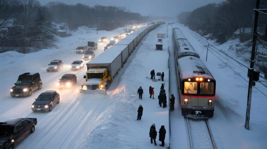
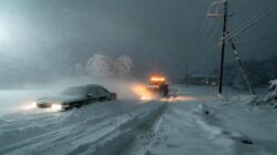
The change never feels sudden until it is. At 3 p.m., car tires still hummed on wet asphalt, commuters watched tail lights and scrolled on their phones at red lights. By 4 p.m., those same roads were turning into white tunnels. Plows that had just finished a pass found their tracks gone, swallowed by drift after drift. Drivers gripped their steering wheels as the horizon vanished, the world shrinking to a shaky pair of headlights in the mirror. What looked like an ordinary winter afternoon had become a slow-motion trap.

Weather experts say this is exactly what scares them about this storm. Forecast models show narrow bands dumping snow at absurd rates of three or even four inches an hour right over key transportation routes. That 55-inch number isn’t spread gently over a week but packed into a window so tight that plow schedules and salt depots and shift rotations start to look like wishful thinking. One meteorologist described it bluntly on local radio by saying you run out of space to put the snow. The math turns brutal very quickly.
We already witnessed these scenarios in actual events. During Buffalo’s 2014 Snowvember storm parts of the city received almost 7 feet of snow. Drivers became trapped on highways for the entire night and building roofs collapsed under the weight. Another major storm hit New York in 2022 and forced the closure of the Thruway when snow bands remained stationary over the same area for extended periods. Trains remained at platforms not due to damaged rails but because employees could not get to the stations. Truck drivers stayed in their vehicles & carefully managed their fuel to prevent engines and themselves from freezing. Local officials remember these incidents clearly. They serve as examples of situations that officials are working hard to prevent from happening again. They’ve
What makes this storm warning more chilling is the way different systems interlock — and then fail together. Road crews can cope with a lot, but when snow falls faster than plows can cycle, lanes narrow, then vanish. Once trucks can’t move, ambulances and buses fall in line behind them, or turn back. Rail networks depend on workers driving in, power staying on, switches not freezing under piles of snow. Air travel? It’s another domino. When forecasters talk about “overwhelming road and rail systems”, they’re not being dramatic. They’re describing a chain reaction where one clogged arterial route quietly disconnects a whole region from itself.
How to think — and act — when the snow doesn’t play fair
The most practical move happens before the first flake sticks. Local officials are urging residents to treat this warning as a timer, not a suggestion. That means filling prescriptions now, charging power banks, topping up fuel, checking windshield wipers and washer fluid while you can still see the hood of your car. If you rely on public transit, download offline maps, note alternative routes, and talk with your employer about remote work or flexible hours. The goal isn’t heroics. It’s reducing the number of people forced to move when the roads and rails can no longer cope.
For people who need to travel, the guidance is straightforward but mildly frustrating: reduce your distance, move slower and lower your expectations. Start your journey earlier than seems necessary. Keep your car supplies basic and useful with items like a blanket, snacks water, phone charger, small shovel and sand or kitty litter for traction. When taking trains, pack as if you might encounter an unexpected delay by bringing an extra layer of clothing a battery pack and some food that doesn’t come from a vending machine. Let’s be honest: nobody actually does this every day. However, when severe storms hit, these additional precautions stop seeming excessive and start seeming like basic common sense.
On a human level, this kind of forecast creates a specific tension. People remember past storms that fizzled and feel foolish for having panicked. They also remember the ones that didn’t — the nights of stuck cars and missed calls. One emergency manager put it this way:
If we handle this situation properly then people might claim we went too far with our response. That does not bother me at all. The other option would be to sit back and watch the identical error happen again.
➡️ Psychology explains what walking with your hands behind your back really reveals about your personality and state of mind
➡️ Does banning cars from city centers save urban life or kill businesses and freedom of movement
A rare early-season polar vortex shift is developing right now. Experts say its intensity is almost unprecedented for February. This weather event has caught the attention of meteorologists around the world. The polar vortex is a large area of cold air that normally sits over the Arctic region. It rotates counterclockwise and stays contained by strong winds high up in the atmosphere. When this system becomes unstable it can shift or even split apart. Cold Arctic air then spills southward into regions that typically experience milder winter conditions. This particular shift is unusual because of when it is happening and how strong it appears to be. February is generally too late in the winter season for such dramatic polar vortex disruptions. Most significant events of this type occur in January or earlier. The timing makes this situation particularly noteworthy for climate scientists and weather forecasters. The intensity of this shift is what really sets it apart from previous events. Measurements show that the disruption is reaching levels rarely seen in historical data for this time of year. The strength of the displacement could lead to significant weather impacts across multiple continents. Researchers are monitoring the situation closely to understand what might have triggered such an unusual event. Several factors could be at play including ocean temperature patterns & atmospheric conditions. The interaction between these elements may have created the perfect conditions for this rare occurrence. The potential consequences of this polar vortex shift are significant. Regions across North America, Europe and Asia could experience colder than normal temperatures in the coming weeks. Some areas might see late-season snowstorms or prolonged cold spells that extend well into early spring. Weather prediction models are working to forecast exactly where and when the coldest air will arrive. The complexity of this event makes precise predictions challenging. However, the overall trend points toward a notable cold outbreak affecting millions of people. This event serves as a reminder of how dynamic our atmosphere can be. Even in an era of climate change extreme cold events can still occur when the right conditions align. Scientists will study this polar vortex shift for years to come to better understand these powerful atmospheric phenomena.
The return of the aircraft carrier Truman sends a troubling signal to the US Navy as it prepares for future conflicts. The USS Harry S. Truman recently returned to its home port after completing a deployment that lasted longer than expected. This return has sparked concern among military analysts and Navy officials who worry about the message it sends regarding American naval readiness. The aircraft carrier had been operating in critical regions where tensions remain high. Its departure from these areas creates a gap in American military presence at a time when potential adversaries are watching closely. The Navy now faces the challenge of maintaining adequate coverage across multiple theaters of operation with limited resources. Military experts point out that the Truman’s return highlights a broader problem within the Navy. The service struggles to keep enough carriers deployed to meet all its commitments around the world. This situation has worsened as maintenance requirements have increased and the fleet has aged. The timing of this return proves particularly awkward. Several global hotspots demand attention & the visible presence of American naval power. When a carrier leaves its station it creates uncertainty among allies who depend on US military support. It also provides an opening for competitors to expand their influence in regions where America seeks to maintain stability. Navy leadership must now balance the need to give crews rest & perform necessary maintenance against the strategic requirement to project power globally. The Truman’s crew deserves time at home after an extended deployment but the operational demands continue without pause. This situation reflects the tension between what the Navy wants to accomplish & what it can realistically achieve with current resources. Building new carriers takes years and costs billions of dollars. In the meantime the existing fleet must cover an expanding list of missions. The return of the Truman serves as a reminder that even the most powerful navy in the world faces limits. These constraints become more apparent as rivals invest heavily in their own naval capabilities and challenge American dominance at sea.
The United Kingdom is constructing a massive machine designed to manipulate plasma in multiple directions to advance fusion power development. This ambitious project represents a significant step forward in the quest for clean & virtually unlimited energy. The device will test new methods of controlling the superheated plasma that fuels fusion reactions. Scientists and engineers are working on technology that could revolutionize how we generate electricity. The machine aims to solve one of the biggest challenges in fusion energy by keeping plasma stable long enough for reactions to occur. Fusion power works by combining atomic nuclei at extremely high temperatures. This process releases enormous amounts of energy without producing long-lived radioactive waste or greenhouse gases. However containing and controlling plasma at temperatures hotter than the sun has proven extremely difficult. The new facility will experiment with different magnetic field configurations to hold the plasma in place. Researchers hope these tests will reveal better ways to maintain the conditions needed for sustained fusion reactions. This project builds on decades of fusion research conducted around the world. While commercial fusion power plants remain years away, each advancement brings the technology closer to reality. The United Kingdom’s investment in this experimental machine demonstrates continued commitment to developing fusion as a viable energy source. The facility will provide valuable data that scientists can use to design more efficient fusion reactors. Success in these experiments could accelerate the timeline for bringing fusion power to the electrical grid and transforming global energy production.
➡️ By planting over 1 billion trees since the 1990s, China has slowed desert expansion and restored degraded land
➡️ After four years of research, scientists conclude that working from home makes people happier, even as managers resist the findings
➡️ Most people focus on cutting big costs and miss this daily drain

That mindset also applies at home. A quick check-in with elderly neighbors, a ride offered to someone without a car, sharing real-time updates instead of rumors — these tiny gestures soften the edges of a brutal forecast.
- Think local: Who around you is most vulnerable if transport shuts down?
- Think timing: What can you move or cancel before the snow walls you in?
- Think patience: Delays and closures are a safety tool, not a nuisance.
When infrastructure meets its limits, the story is about people
What lingers after a storm like the one now on the radar isn’t just the snowbanks. It’s the stories told in break rooms and kitchens: the nurse who walked the last mile home because buses stopped running, the mechanic who slept on a shop couch after plows got pulled off the road, the train conductor who kept announcing updates to a car full of tired strangers, trying to sound calm. On a weather map, a 55-inch forecast is a color gradient. On the ground, it’s hundreds of thousands of decisions, large and small, threaded through a shared risk.
We often think we can handle winter if we have good equipment or a bigger car. This warning challenges that belief. It shows us that sometimes conditions get so bad that determination & powerful vehicles cannot overcome the reality of ice wind and poor visibility. Snow affects everyone the same way regardless of their vehicle type. What really counts is when communities decide to prioritize safety instead of convenience, when leaders speak truthfully about dangerous possibilities, and when we recognize that choosing to stay home is a smart decision rather than giving up.
There’s also a quieter question humming under all the radar loops and emergency alerts. Will we treat this storm as a fluke or as another data point in a pattern of more intense, more disruptive weather events? Climatologists warn that what used to be called “once-in-a-generation” is edging closer to “every decade” in some regions. That doesn’t mean every winter becomes an apocalypse of snow. It does mean that how we design roads, power lines, rail hubs — and the lives built around them — will keep getting tested. Sharing this forecast isn’t just about fear. It’s about widening the circle of people who get to decide how to respond.
| Point clé | Détail | Intérêt pour le lecteur |
|---|---|---|
| Vitesse des chutes de neige | Jusqu’à 3–4 pouces par heure dans certains corridors de transport | Comprendre pourquoi les routes et rails peuvent être vite saturés |
| Fenêtre temporelle serrée | Jusqu’à 55 pouces concentrés sur une période relativement courte | Mesurer le risque réel, au-delà du simple total de neige |
| Préparation personnelle | Adapter ses déplacements, son kit et ses plans de travail en amont | Réduire ses chances de rester bloqué ou en danger |
FAQ :
- How serious is a forecast of up to 55 inches of snow?It’s not just a “big storm”; it’s a high-impact event that can paralyze roads and rail lines, limit emergency response and disrupt daily life for days, especially if it falls in a tight timeframe.
- Will public transport keep running during the worst of the storm?Transit agencies try to maintain core services, but they may suspend routes or whole lines if visibility drops, tracks clog or staff can’t safely reach depots and stations.
- Is it safe to drive if I have snow tires and four-wheel drive?Those help, but they don’t change the fact that you can’t see through a white-out or stop quickly on ice; officials often warn that staying off the road is safer than relying on equipment.
- What should I do at home before the storm hits?Stock basic food, water and medications, charge devices, check flashlights, and talk with family or neighbors about who might need help if travel becomes impossible.
- Could the forecast be wrong or overblown?Exact totals can shift, but the underlying risk — rapid, heavy snow capable of overwhelming infrastructure — is what forecasters are flagging, and that’s worth planning around.