
A long stone wall hidden on the seabed near the Atlantic coast of France is making archaeologists reconsider what coastal hunter-gatherers were capable of organizing and building before rising seas covered their land. The discovery challenges previous assumptions about the abilities of these ancient communities to create lasting structures & preserve knowledge across generations.
An Ancient Underwater Discovery That Challenges Early Human History
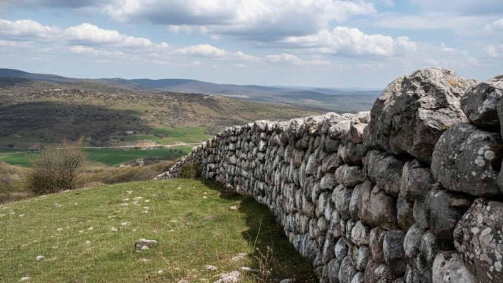
The structure lies off the island of Sein at the western tip of Brittany in waters that sailors know better than archaeologists. It first appeared on detailed seafloor maps as a suspiciously straight feature running across the otherwise rugged bottom. French geologist Yves Fouquet spotted the anomaly while studying sonar data. The line looked too regular and too deliberate to be a random ridge of rock. That clue triggered a series of dives between 2022 and 2024. Under about 9 metres of water divers found an unmistakably human-made monument. It was a long stone wall built on what was once dry land. On its upper side dozens of granite blocks stand in two nearly parallel rows. These are not small stones scattered by waves. Many weigh several hundred kilos and have been set in a regular pattern. That layout rules out a natural formation and points straight to a collective building effort. Radiocarbon & sea-level data place the construction between roughly 5800 & 5300 BC. At that time the shoreline looked very different. Sea level in the region sat about 7 metres lower than today & the island of Sein stretched much farther. It was perhaps fourteen times its current size. The wall was built on dry ground on a low-lying coastal plain. Only centuries later did the Atlantic creep inland and flood the landscape. The rising water hid the monument beneath the waves.

When Hunter-Gatherers Built on a Monumental Scale
The structure dates to the late Mesolithic period right before agriculture arrived in Brittany. Historians believed this era was dominated by small groups of hunter-gatherers who moved frequently with the seasons and left minimal evidence of their presence. The wall challenges this traditional view. Its considerable length and precisely positioned stones along with the massive amount of material used indicate that many people worked together following a deliberate design over several months or possibly years. This degree of coordination contradicts the conventional picture of loosely organized groups that constantly moved from place to place. The evidence points instead to more permanent settlements along resource-rich coastlines where people could rely on consistent fishing areas and return to the same seasonal locations regularly.

Uncovering the Purpose Behind the Mysterious Stone Structure
Researchers writing in the International Journal of Nautical Archaeology discuss several possible uses for the structure. None is certain yet but some ideas stand out. Coastal fish trap: A long wall could have guided fish into enclosed areas at low tide making mass capture easier. Shoreline barrier: It may have worked as a primitive sea defence breaking waves and protecting a settlement or lagoon behind it. Territorial marker: The wall might have marked important access rights to fishing grounds or landing places. Large stone fish weirs are known from later periods in northern Europe and North America. In those systems walls or fences running across tidal zones pushed fish into traps as the water fell. The newly found Breton wall could be an early version of that same logic built by people who intimately understood tides & currents and seasonal migrations of fish. Another possibility is that communities were already responding to a slowly rising sea. Post-glacial meltwater was still feeding the oceans. Low-lying coasts like western Brittany saw gradual but relentless flooding. A wall along a vulnerable stretch might have slowed erosion or sheltered a lagoon used as a safe harbour for boats.

A Prehistoric Coastline Lost Beneath Rising Seas
Seven thousand years ago the landscape around Sein looked surprisingly green & open. There were no fields yet but the area had dunes and wetlands and shallow bays that were full of shellfish and fish & seabirds. Small groups of people likely moved back and forth between the forested areas inland and the coast as they followed game animals and looked for seasonal resources. The sea level continued to rise slowly and those calm lowlands became mudflats and then eventually turned into seabed. Places where people had lived and made fires and buried their dead & worked all ended up underwater. Most structures made of wood rotted away over time and only stonework like this wall remained as evidence. Folklore in Brittany often tells stories about drowned cities & lost lands that lie beyond the current shoreline. Some archaeologists think these legends might contain distant memories of real events when people had to retreat from rising water. These retreats happened over many generations and the stories were told long after the original land had vanished.
 7-minute chair sequence after 60 rebuilds core strength better than planks for safer control
How Submerged Sites Are Transforming Our Understanding of the Past
The discovery close to Sein demonstrates that substantial proof of ancient coastal existence remains hidden past today’s waterline. Throughout many years researchers studying prehistoric times concentrated mainly on cave systems and interior flatlands along with large stone structures such as the well-known upright monuments at Carnac. Underwater landscapes presented greater challenges for investigation. Scientists needed sonar equipment and trained divers while also depending on favorable weather conditions. Modern methods have made these previously unreachable areas valuable for learning about early navigation practices and fishing methods as well as how people adjusted to changing climates.
How a Faint Sonar Signal Revealed an Ancient Stone Structure
| Feature | Details |
|---|---|
| Puzzle Style | Find the Differences Challenge |
| Focus Area | Enhancing Visual Attention |
| Difficulty | Intermediate Level |
| Time Constraint | Brief, Quick-Play Rounds |
| Skill Development | Boosts Observation and Focus |
What This Discovery Reveals About Future Sea-Level Change
Modern coastlines face rising water levels, stormier weather & eroding beaches. The Breton stone wall provides a long-term view of how societies respond when the land’s edge becomes unstable. Mesolithic communities lacked concrete sea walls satellite data or flood insurance. They relied on careful observation, communal projects and flexible lifestyles. They adjusted hunting routes, moved camps inland and sometimes built physical structures to extend the usefulness of valued places. The monument near Sein suggests an intermediate approach: resistance before retreat. People attempted to manage the changing shore with stone, knowledge of tides and shared labor. That strategy may have worked for a few generations before the ocean ultimately prevailed.
Essential Concepts That Help Explain This Remarkable Find
The site introduces several technical terms that help explain what researchers found: Mesolithic refers to the middle stone age. This period falls between the Paleolithic era of cave hunters & the Neolithic era of early farmers. In western Europe it lasted roughly from 10,000 to 5000 BC. Neolithic describes the time when agriculture and permanent villages emerged. Later on monuments like stone circles & alignments appeared. In Brittany farming started around 5,000 BC. Submerged landscape means former dry land that now sits underwater. This flooding often happened when sea levels rose after the ice age ended. These underwater areas can preserve ancient riverbeds & forests along with human structures. Understanding the wall as part of a submerged landscape shows that the site is not just an isolated oddity. Instead it represents one surviving piece of a much larger coastal system. That system once included paths and campsites along with fishing spots and ritual places that are all now hidden underwater. For visitors to Brittany today this story adds meaning to a windy cliff walk. Just beyond the breaking waves and under a few metres of cold Atlantic water sits evidence that people here were already working together 7,000 years ago. They understood the tides and knew how to reshape stone. The gap between past and present seems smaller when you realize something important. The same rising sea level that covered their wall is now moving inch by inch toward our own shorelines.